Friday, December 28, 2007

CHHOTA KAILASH -- NATURAL BEAUTY, PEACE AND SERENITY

OM Pravat and Adi Kailash also known as Chhota Kailash is an area of great natural beauty, peace and serenity.
During this trek one gets an opportunity to view the snow peaks of Annapurna, thick forests, water falls and wild flowers.
JONGLINGKONG is another name of Chhota Kailas (6191m) while its small but beautiful lake is called Parvati Tal.
The reflection of the peak in the lake is really fascinating.
There is a temple near the lake, which is sometimes visited by swan-like birds. A little distance from here is to be found the remains of a dry lake.
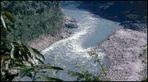
Along the river Kuti are two passes Lampia Dhura and Mangsa Dhura, both leading to Tibet.
The ITBP and SPF personnel will tell whether one can cross the Sinla pas to reach Dedang.
If this is not possible one will have to return.
If there is little or no snow, one should set out early in the morning to cross the pass.
The route to Sinla pass is under a heavy blanket of snow.
One can see the Chhota Kailas peak constantly from there.
The traditional trekking route is from New Delhi to Kausani, Dharchula, Pangu, Sirkha, Galgad, Malpa, Budhi, Navidang, Gunji, Kutti, and Jollingkong to Adi Kailash.
And remember the grade of trekking is strenuous, and the duration is 23 to 24 days.Enjoy your time here in the lap of Himalaya, and forget about metro city for some time.

Saturday, December 22, 2007

PINDARI GLACIER –GRANDEUR OF THE HIMALAYA

There are many glaciers in the Himalaya, but Pindari glacier is the most popular, since it is most easily accessible within the reach of common trekkers. The rewards are many beautiful mountains, flora and fauna, water falls, and snowy ranges all within your range.
There is high elevated circumference of 110 kms around Nanda Devi, Pindari glacier at the lower edge of this circumference.
The Pindari glacier in the Bageshwar dist of Kumaon Himalaya, in the Indian state of Uttaranchal, is in the Nanda Devi and Nandakot Peaks, 5 kms long, 6m high and 2.5m wide, the altitude is 4000m to 5000m.
The Pindar river emerges from this Pindari glacier.
The traditional route from Delhi is as under.
From Delhi to Bageshwar - 16 hour drive, smooth no problems for vehicles.
Bageshwar is the last town, with STD booth, last place of gas station, local govt accommodation facility is available here.
From Bageshwar to Song, at an altitude of 1300 m, the distance is 40 kms and it should take 2 hours by jeep, the roads are not good but the worst as well.
From Song , walk the distance to Loharkhet , the walk is long, hard and dry, altitude 1800 m, the local govt has some accommodation facility.
From Loharkhet to Dhaukri to Khati to Dwali to Phurkiya to ZERO POINT OF PINDARI GLACIER.
From the distance the frozen streams look like puzzle, Pindar river looks like a mystery, always trying to fight with the ice which tries to choke it and the river always trying to cut into the glacier.
The trip to Pindari glacier ends up to a arbitrary zero point, beyond this point the visitor shall not able to see the Nanda Devi and still Himalayan Peaks are beckoning .

Saturday, December 15, 2007

MELGHAT TIGER PROJECT- CONFRONTATION BETWEEN MEN AND TIGERS

MELGHAT TIGER PROJECT, 100 kms from Chikhaldhara in the Amravati Dist of Indian state of Maharasthra., is one of the yet another place for the adventures and naturist s to study the tigers and other mammals in nature’s surroundings, and those who are interested in botanical subjects , they have yet another opportunity for studying the tropical dry, deciduous forests.
Nature has granted protection to the Melghat in the form of only few entry points in the rugged topography.
Melghat tiger sanctuary has an area of 800 sq.kms,. is a home of 41 species of mammals. These include the tiger, leopard, sloth bear, gaur, jackal, hyena, wild boar, langur, and number of sub-species of deer family.
There are almost 250 types of birds some of them as rare, which you can find only in dense forests.
There are some villages in the core section of the forests, mainly dependent on forests, for the collection of fruits, wood and medicinal herbs.
One shall find most original herbs and fruits that are used for medicinal purposes.
There are instances of confrontations between men and wild animals, in the year 1998; there were 11 cases of persons injured, 1 by tiger and 10 by sloth bears.
The population of some important animals, tigers 73, leopards 79, sloth bear 187, the other animals counted together totaling 10 thousand.
There are number of tributaries of river Tapti which provided natural water source for the forests.
Maharasthra Tourism Development Corporation has resort with fine accommodation and eatery facilities at Chikhaldhara.
The village people in the forests are and the forest dept staff is very friendly and helpful to the people.
If you wish to see the wild animals roaming freely in the forests come and see them here, and be careful to keep the escorts, tigers may rather prefer you as their prey rather than guests.

Tuesday, December 11, 2007

ABI GAMIN --- ONE OF THE STALWARTS WITH GLACIERS AND CLIMBING.

A large of peaks in Himalayan are stalwarts and not open for the climbers, especially for the foreigners, mainly for the securities reason, since Tibet is the immediate neighbor.
Abi Gamin is one of these tall stalwarts, conquered only a few times.
Abi Gamin situated in the Chamoli Dist of Indian state of Uttarakhand, at the elevation of 7355 meters, is a serious challenge for the hard-core climbers.
It is hardly 2 kms from Kamet, another stalwarts of Himalaya.
It is between the famous passes, Manna pass and Niti pass on the Indian – Tibet borders. Alaknanda and Dhauli Rivers is the watershed of Abi Gamin.
More than a dozen expeditions since 1848 were done to conquer Abi Gamin but all have failed, until however, in year 1950 when the expedition of Anglo- English team succeeded in reaching the peak, the operation had been thru Tibetan side.
Later expeditions had been in the year 1953 and 1955 both from the Indian side of Kamet.
Whichever way you go be ready to face the glaciers, the hidden valleys, the killing cold and tedious climb.
For security reasons, the permission to these expeditions has to be cleared from Govt of India.
This expedition is for hard-core climbers. Keep necessary gear, the tents, the climbing tools, sturdy shoes and clothes, and spirit of daredevil.

Friday, December 7, 2007

RONGBUK GLACIER -- EXPEDITION TO MOUNT EVEREST.

Probably the climbers who wish to conquer the Mount Everest shall first hear the name of Rongbuk Glacier and Rongbuk Monastery.
Mount Everest is the source of Rongbuk Glacier; there are two tributaries, East and West Rongbuk Glacier.
The climbers to reach the base camp of Mount Everest must go thru Rongbuk Glacier.
In 1921, George Mallory first explored Rongbuk Glacier and Rongbuk valley to conquer the Mount Everest.
Rongbuk Monastery founded in 1902, which lies at the foot of Rongbuk Glacier is the highest monastery ( 5100 ft) , it is only 200 meters down from the base camp of Mount Everest , has a dirt road facility now, but in 1921 when George Mallory came here he had to walk 5 weeks from Darjeeling to reach here.
From Rongbuk glacier the view is said to be most dramatic view , a panorama of Mount Everest with other peaks, often shrouded in clouds and mists, one shall see the imposing head of ice and granite , Mount Everest.
In 1983, the renovation work was undertaken by Govt and some type of basic guest house and a small restaurant has been established.
If you want to conquer Mount Everest, first try to live by Rongbuk Glacier, from there make your judgments whether you are fit to go further.

Sunday, December 2, 2007

PANGONG TSO – LAKE IN HIMALAYA. – A GEOLOGIST’S PARADISE

Himalaya is a big icy brother of India, with numerous hills, peaks, glaciers and number of rivers originating from Himalaya, nourishing different cultures, Himalaya is a unique identification of India.
On the north to east to west, there are various states; out of these Ladakh is the best known state of mountains.
Pangong Tso or Pangong Lake, Tso means in Ladakhi Language Lake, is the unique.
The journey of 160 kms from Leh, capital of Ladakh is the beginning point of our tour to Pangong Tso.
The journey thru rugged tracks, cut from the mountains, the very few small villages, the people waving , the only people you shall see the most are the Indian Army Personnel.
Mind you the visitor shall be crossing the Changla Pass (17350 ft), the third highest pass in the world. The oxygen is scarce but Army people generally help to the needy one. Although Indians are granted the permission individually, the foreigners are granted the permission in groups accompanied by some reputable company escorts.
Pangong Lake is the 13900 ft, the water is always cool and though it is saline it freezes to ice in winter. The water is cold, clear and extremely salty, one can with ease pick pebbles and by luck may find some fossil in it. Hence it is the paradise of Geologists. Geologists research here for the existence of life cycles in the lake.
The atmosphere is clear, no plastic garbage no crowds, thanks to the Indian Army , they are keeping the things in order.
The region around is very suitable for Kiang, a mammal of horse family.
The wet land is the visiting place of migratory birds, Siberian Crane, keeping photographers busy.
Mind you the nature is adverse, warning; the icy chunks freezing the time, the nearest rest houses are few kms away in village with preliminary facilities. You must reach Leh for rest.
This trip is for the off traditional vacations places; here the visitor is in the arms of nature.
Pangong lake is divided in between India and china army people of these two nations are guarding.
Boating is not permitted.
But lake is well –known for it’s wet land, which is now covered as protected under Ramsar Convention.

Tuesday, November 27, 2007

KHATLING GLACIER TREK – STANDING WALLS OF GRAVEL MUD

Garhwal region of Himalaya is really a heaven for trekkers, trekkers of all sorts, easy, moderate and hard core, every sort of trekking is available here.
Khatling glacier trekking in the Tehri dist is one of those moderate trekking grade. This glacier is the source of River Bhilagna.
The glacier is surrounded by stunning mountains snow peaks, Jogin group (6466met), Spetic Pristwar (6905met), Barte Kauter (6579met) Kirti Sthumb (6902met) and Meru.
The moraines look like standing walls of gravel mud.
The altitude of the Khatling trek is 4000 met.
The whole trek though can be termed as moderate level of trekking, tents, camping and other tools must be obtained from Rishikesh or Delhi.
Traditional route is from Rishikesh. From Rishikesh the visitor has to travel to Ghuttu (150 kms.). Public buses or private taxis are available for this part of the journey.
From Ghuttu, the trekking begins 45 kms. Up and down thru picturesque villages like Reeh, Gangi, Kalyani, Bhelbagi, the journey is thru Kharasao forests and green meadows, and all being surrounded by peaks and valleys of Himalaya.
The entry to Bhilangna valley is famous spot of camping.
The whole trek consumes almost 11 to 12 days. There are number of tour organizers from Rishikesh, Dehradun and Delhi who organize the guided tours for trekking.
The Khatling glacier zero point is a spectacular point with everywhere snow and high peaks all around.

Friday, November 23, 2007

KANGCHENJUNGA------PRISTINE BEAUTY—WHITE WALL HANGING FROM THE SKY.

Kangchenjunga, 8586 meter, is the third highest mountain in world, first being Mount Everest and the second is K2.
Kangchenjunga, in Tibetan means “The Five Treasures of Snow”; the five treasures are gold, silver, gems, grains and holy books.
Though Kangchenjunga has variety of spellings, and spoken differently in Tibet and Sikiim (India), and Nepal the spelling given here is well accepted by usage.
Kangchenjunga has five peaks; out of these four are above 8400 meter. On May 25, 1955 the main summit was first climbed by a British Expedition , but the belief of the Sikkemese, who told that the peak is sacred, stopped a few feet from the top, since then most climbers honor this custom , they stop a few feet from the top.
Kangchenjunga has great many ridges forming a giant X shape.
Kangchenjunga is very remote in Nepal and has the difficult access in India, hence it has remained almost unspoilt, climbing and trekking is for hard-core men only.
From all over the world, people come over to a hill station Darjeeling (India), from where Kangchenjunga which is only 40 miles. Distant, to take the closest possible view without risking the life.
In both the countries, Nepal and India, Kangchenjunga areas are treated as conservation parks. In Nepal, Kangchenjunga sanctuary is home of Red Panda and other snow animals. In both countries enough efforts are done to conserve the forests.
There traditional two routes for trekking to Kangchenjunga, one is from Sikkim (India) starting Gangtok and other one is from Kathamandu (Nepal)
“The Himalayas must be approached humbly, respect their beauty, their majesty, and their power, and they will treat you as you deserve.” Frank Smythe said in 1932.

Tuesday, November 20, 2007

TREKKING AT MILAM CLACIER – A CLOSE VIEW OF FORBIDDEN LAND OF NANDA DEVI SANCTUARY.

Want a thrilling treacherous trekking in Himalaya?
Heard the name of Nanda Devi Sanctuary? Probably the hikers, serious trekkers and adventures looking men always dream of roaming in the Nanda Devi Sanctuary. But Nanda Devi Sanctuary is now closed to visitors from all nations, including those from India.
The only thing to satisfy is a trekking at Milam Glacier Trekking; this trekking is the only way that one can have the most possible closest view of Nanda Devi Sanctuary.
The Himalayan region of Kumaon is rich in natural beauty, and Milam Glacier is largest in Kumaon region.
A trekking at Milam Glacier has everything that a trilling story can have, a tough trek, unpredictable weather in the flora and the only traffic of trekkers and occasional goats wandering here and there.
Milam trekking is almost a round trip around Nanda Devi Sanctuary, of course from outside. At an altitude of 4300 met and spread around 35 sq kms, Milam Glacier is guarded by 52 high peaks of Himalaya.
Three most important rivers, Kuti Yangti, Dhauli and Gori are in this Milam Glacier zone.
An advise to the trekkers , keep sufficient supply of suitable clothes, shoes, food that can last 10 days, camping goods , portable gas cylinders and of course a lot of strength and courage, trekking at Milam Glacier is not for easy-going people, it is for serious trekkers.
Villages that you come en-route are small, and in fact the Milam Village which is 3 kms away has population that can be termed as zero only.
The traditional route is Delhi, Haridwar, Gwaldham, Musiyari, Bogudiyar, Rikot, and the target Milam Glacier.
Enjoy the live show of gigantic masses of sliding snow at Milam glacier.

Thursday, November 15, 2007

BICYCLING IN KERALA – A TEST OF STREGTH FOR CYCLE AND CYCLIST.

Bicycles are used as recreation at all ages, the old and the young, cycling adventure has that flexibility where the person has time to travel leisurely and stop at whatever places he likes.
Mountain bicycling adventures grew up in the 20th century as a very popular way of vacations.
If you wish a bicycling adventure tour, enjoying the nature’s wealth, then the best place is cycling tour in Kerala.
Cycling thru endless rough and rocky tracks in the mountains, tea estates spread along, blue clear sky and breath taking downhill scenery that is what bicycling in Kerala is.
Escape the gloomy cold in Europe and enjoy the sunny tropical cycling in Kerala.
Bicycling in Kerala shall take everywhere where other tours in taxies fail, in the innermost parts of Kerala. Kerala has the title of top ten Paradise Found status given by National Geographic.
Bicycling in Kerala shall take to a leisurely trip to Cochin , a port since Roman times, among palm trees and blue waters, or to a back water trip ,thru lakes and rives with your bicycle always on hand , to take at the moment to leave the boat and wander along the banks, or enjoy the vegetation along the river and small villages, or wander amidst the Munnar , which has highest tea estates in the world under the shadow of high peaks.
If you are out of India, contact the airlines, whether they can carry your cycle in whole or in fold, otherwise the tour operators shall make arrangements for cycles on hire here in India.
Keep with you a helmet and spares, especially the spokes and chains, since cycling tour in Kerala is test of strength of both cycle and the cyclist as well.

Monday, November 12, 2007

NANDA DEVI- BLISS-GIVING GODDESS

Nanda Devi, the second highest mountain in India, and the highest entirely in India (since Kanchenjunga is divided between India and Nepal) is locally worshipped as the patron goddess in Uttarakhand Himalaya. It is situated in the Uttarakhand state of India.
Nanda Devi has two peaked massif, on 2 kms high ridge, west –east side, the western massif is known as main Nanda Devi( 7816m)east massif is known as Nanda Devi east(7434m).
Nanda Devi main summit has typical geography, it has almost insurmountable barrier ring of some of the highest peaks of Himalaya, and twelve of these are 6400m. The interior of this ring is known as Nanda Devi sanctuary.
Nanda Devi is well-known for its large steep rise above local terrain.
Nanda Devi has always tempting the adventurisms , an attempt made by British explorers finally succeeded in entering Nanda Devi sanctuary in the year 1934.but it was in the year 1935 that a team of British American explorers finally succeeded in reaching the main summit.
Attempts were made by CIA to place a listening device to monitor the nuclear activity of Chinese in Tibet; in 1960 the Indian govt. had closed the sanctuary for any expeditions by foreigners or even to the Indians. In the year 1974 the sanctuary was re-opened for the expeditions by foreigners , locals and trekkers , and the damage to the eco system was so vast that the sanctuary was again closed 1983.
Nanda Devi sanctuary and the bio-sphere is now beyond the limit for any expeditions, and except in 1993when a team of Indian army was deputed to undertake the expedition to clear the garbage and check the whole scene.
Nanda Devi shall always remain a challenge to the dare-devils, if at all it is again re-opened.

Friday, November 9, 2007

ROHTANG PASS - PILE OF CORPSES

For the people who yearn for the touch of danger with a safe distance Rohtang Pass at the elevation of 4000 meter in Himachal Pradesh is very luring.
Rohtang pass connects the Kullu valley with Lahul and Spiti valley.
Rohtang pass is almost 50 kms from Manali another hill station and naturally visitors from Manali make it a point to visit Rohtang pass as well.
This pass is open only from June to September is ill-reputed as the most dangerous because of the unexpected snow storms.
Rohtang pass is the natural divider between the wet lands down lands and dry cool deserts upward which is prominently Buddhist and Tibetan influenced.
At the top of the Rohtang pass is the stream which is source of Beas River.
Passing thru the Rohtang pass one shall see the high mountains high above the clouds , half clad with mountains , almost inaccessible for humans or any living creature, un spoilt, panoramic and breath taking, a view which photographers and visitors shall watch with silence.
Taxies and jeeps are available from Manali; the drivers must be experienced because a least distractions and the death are certain. From the main parking stand, one has to walk the distance to reach the top of the Rohtang pass; a horse ride is also available. It most advisable to start the trip early morning and return before sun set so as to reach safely.

Sunday, November 4, 2007

SUNDARBANS NATIONAL PARK – A HOME OF UNTAMED AND FERAL CREATURES. COUNTRY OF BENGAL TIGERS

Like roaming in the jungles like Captain Cook or Robin Hood? Then put your foot in the Sundarbans National Park

Sundarbans lies at the mouth of Ganges spread across Bangladesh and West Bengal of India.
This national park is virtually cut off from human because the only access is by waterways, the launch service is available from Port Canning which is connected to Calcutta and other towns either by road or railways.
Sundarbans largest mangrove forest and Sundarbans National Park a home of Bengal both are listed in World Heritage List. The dreaded Bengal Tiger and so many other animals, untamed and feral reside here.
It is estimated that are 400 Bengal Tigers and 30,000 spotted deer alone here.
To wander here is like reminiscence of past life.
Fox jungle cats, Indian porpoise, wild ibis, are roaming here, and to above all the Bengal Tiger the king of this jungle.
But moving in the jungle one must be always on alert. You must have a guide and an armed escort with you.
Tigers attack from behind therefore the adventurists must cover their back well, people wear stiff pads, which rise up to the neck. The Bengal tigers kill here almost 100 to 250 people each year, so be careful.
Sundarbans has humid climate so the best season for adventure is December to March, when the air is dry, it is almost impossible to enter the core section of the jungle during monsoon when the roads are jeep treks are washed up or submerged by vegetations.
There are private tours organizations but it is really advised to take the tour organized by WBTDC which has it’s office in Calcutta.
A permit is necessary for Indians as well Foreigners, apparently for conservation purposes.
Tourists lodge and tiger camps facility is very well available in this Sundarbans National Park adventure.

Wednesday, October 31, 2007

TREKKING AT GANGOTRI - ASCEND AND DESCEND

For the people who wish to roam in the hills of Himalaya in the spirit of vagabond , and have enough stamina of constant ascending and descending, the ideal trekking is available at the Gangotri to Kedarnath trekking.
Gangotri and Kedarnath are both places of great pilgrimage for Hindus.
To begin the trekking one has to reach to a small town namely Mala by motor , in the Himalayan region the railways has very limited access because of the hilly regions the installation of railways is very costly.
At Mala get refreshed and be prepared for trekking.
From Mala one has to cross river Bhagirathi and reach almost easy dusty trek to Sauri Ki Gad.
From here onward the trek is ascending until you reach Belak.
Get refreshed again at Belak, one shall definitely need it.
From Belak to Buddha Kedar the trek is descending way thru the valley regions, the high mountains around you. This is the place the tourists shall enjoy the most, the trek is thru dense Himalayans jungle all around you full of different vegetation , birds singing in heavenly songs . a perfect for naturalist to loiter.
Fom Buddha Kedar Panwali , again prepare yourself for ascend thru picturesque hills traced fields , small huts of people and valley downstairs and beckoning peaks everywhere.
The trekking consists of almost 20 kms and depending upon the zeal and energy of the trekker it may take 2 to 3 days.
From May to October is the best time for this trekking.
Yes guided tours and guides are available at Mala , the gear like trekking shoes etc should however purchased from the other major cities nearby like Dehradun or Rishikesh.
Keep necessary supplies of water and eatables , though small huts and side shops offer you a place to rest and eat.
At Kedarnath where the famous Shiva temple is there, one shall get some nice places for accommodation and food.

Sunday, October 28, 2007

MOUNT KAMET - FACE THE FORCEFUL WIND

In India in the Himalayan Mountains there are several peak and ranges standing high to challenge the adventure spirit of men.
Kamet is one of them. Kamet is in Chamoli dist of Uttarakhand in the Grahwal region of India. Kamet is a part of Zaskar range of Himalaya, the heights is 26000 ft.
The explanation of the name Kamet as is Grandmother of Snow Chains.
In appearance it appears like a giant pyramid standing with two peaks.
Kamet drains into two rivers namely Saraswati river and Dhauli Ganga River both are tributaries of Alaknanda river.
Since it is near Tibetan plateau Kamet remained least accessible and beyond the reach of so many expeditions. The greatest hurdles in climbing Kamet is the forceful wind that comes from Tibetan Plateau.
There are however additional tools and equipments now a day hence the climb has become somewhat straightforward and easier.
The standard route to climb Kamet is from the East Kamet Glacier. The ascent involves steep gullies, rock walls and glaciers climb. There are usually 5 to 6 camping requirements to reach the summit, and the last summit is very steep.
There is another route from Ranikhet in India.
The convenient expedition starting station is Haridwar near Delhi.
Fro security reason, since the neighboring countries are China and Tibet, a permission of the Govt of India is necessary.
At dawn and dusk the copper colored rocks reflecting on glaciers look like crackling flames bathing Kamet in glow.

Wednesday, October 24, 2007

INDUS RIVER --ENJOY WATER RAFTING

The Indus river which lends it’s name to India itself flows in the cold deserts, it originates from Kailash Mountains near Man Sarovar in Tibet enters the Ladakh passes through the Leh Valley and then goes to Pakistan.
Of the entire rivers originating from Himalayan ranges Indus has the most scenic beauties flowing through mountains, with various monasteries beside the riverbank.
The rafting in icy cold and clear water with rapids of I and II and some III degree is a very awesome experience for the rafters.
There are various rafting tours and one can choose according to his own skill and courage.
The Pheh – Nemu route mostly with grade II and III consisting of 40 kms , rafting in the water with beautiful mountains all around you. This route is for the experienced rafters only.
The another route is Upshi- Khalsey route , is not much difficult and beginners may do rafting here, the graded of the danger is I and II only.
The Spituk –Saspot route is short but the river here is wild and it is recommended for the experts only.
The Spituk –Karo is an excellent opportunity for the learners. Here one can learn skills of the rafting with relatively very low risk of injury.
There are tours operators in Leh providing the rafting equipments on hire and a pilot guides are also available.

Sunday, October 21, 2007

DIRT TRACK CAR RACING - A CHALLENING GAME

Although there are various types of motorcar racing events organized since motorcars started on the road, and racings were organized, dirt track racing has always been a challenging game.
This game was born in USA after World War I and soon spread to other parts of world, with some minor alterations.
Although initially dirt track car racing were performed with the common cars , cars running on the roads, today cars for these races are specifically modified and designed for this purpose.
They have steel frame chassis, aluminum bodies with aerodynamic shapes to gain the speed and reduce the effect of friction. They have generally 800-horse power engine, with 9000 RPMs.
Usually cars are classified within class such as open motor, specific motor and all steel motor.
Usually all car tracks are oval half a mile long, the longer track helps the cars to gain the speed, but increases the damages in the events of accidents.
Each organizers or sponsors have rulebook as to which cars can part-take, so that the skill of drivers can be tested.

Tuesday, October 16, 2007

GLIDER --- FREEDOM FROM THE GRAVITY


A glider is an un-powered aircraft or simple flying machine. They are used for the purpose of sporting activity. The design of the glider enables them to glide through the air currents, and then to touch down for another lift up.
The most common method of launching the glider is to launch the gilder with aero tow or winch.
Once airlifted the glider can be remain gliding in the sky for hours taking the benefit of air currents.
Gliding is an outdoor sport and the nature, which is always unpredictable, is a deciding factor as to how much you can fly. It may happen that you can enjoy the sky and earth for hours or may be forced to ground, when air current do not co-operate. That is why gliding is an adventure of dealing with unpredictable air.
The pilot must be trained and courageous, swift in action to decide the next actions according to the benefits of force of the wind.
Though gliding is relatively new sport in India, it is gaining popularity rapidly.
There are gliding clubs in cities like Pune, Delhi, and Bombay.
The best gliding adventure in India is available at Billing in Kangra Valley in Himachal Pradesh. This is the place where annually a competition of gliding is organized. The topography of Billing is most suitable for the adventures and thrill that the gliders are searching.
The ice-clad Himalayan, the gardens, and the greenery the glowing blue sky give the gliders the most that he wanted.

Sunday, October 14, 2007

KANGRI - LONESOME AND UNPOPULLUTED


For the rock climbers who wish to take moderate risk in rock climbing in Himalayan Mountains, Saser Kangri is the ideal place.
Saser Kangri consists of massif consists of four major peaks of which Saser Kangri I is the highest (7672 meters)
Saser Kangri is the easternmost sub range of the Karakoram Range in India.
Climbing Kangri does not require any great amount of Himalayan climbing experience.
If you have climbed in Himalayan before you can do it here also.
Saser Kangri has most scène tic beauty in Ladakh.
Since this place is not popular it is least polluted in Tibet –Ladakh region.
The adventure starts from Leh, which can be reached from Manali, Manali is yet another vacation place.
Manali itself is connected to Delhi by air.
It is really advised to the climbers to take minimum luggage, keep enough water and energy giving food. Although the local Sherpas are available for luggage carrying, after some climbing you should have minimum weight to carry with you. It is also absolutely necessary to keep one local guide to show the ways and safe ways of climbing.
One must also keep camping goods and warm clothes, especially sturdy shoes.
Near Kangri Buddhist monasteries are also worth visiting.

Thursday, October 11, 2007

ROARING TIGERS - CORBETT NATIONAL PARK


If you love to wander the jungles, and touch the nature in the utmost, a tour to Corbett National Park is ideal for you.
Corbett National Park is situated at the foothills of Himalayan, in India in the Kumaon region in the Grahwal in Uttaranchal Pradesh.
Corbett national park is 300 kms from Delhi and 70 kms from Nainital another hill station.
It is here that you can follow the tiger trails and do some serious bird viewing.
Corbett national park has such a fascinating topography and vegetation that the tour becomes your experience of enchanting moments.
The Ramganga River flowing through the jungles and the dense protected forest is the ideal shelter for the tigers.
There are other animals too, like Hog deer, Sambhar and spotted deer. The Corbett biosphere is heaven for many birds.
Many naturalists would camp here for several days to identify and photograph them.
Along the banks of Ramganga River there are fish eating crocodiles and one must be careful of them.
There are tour operators who can arrange the accommodations and guided tours. The cottages have superior rooms and serve American or Indian lunch as per the choice.
The tour operators have also with them naturalist and jeep drivers to take you thru guided tour of tiger trekking.

Saturday, October 6, 2007

TIGERS- MESMERIZING SAFARIES AT PENCH


Tigers the frighting at the sight animal have their own and prime number in the wild animals dictionary. Tigers are natives of Asia Mainland , the national animal of India, are the biggest in the " cat" family.Bengal Tiger is the most common subspecies of the tigers. Today tigers are found in India, Bhutan, Nepal and Myanmar.
Since natural inhabitants of India, there are numerous tours in various parts of India , since the jungles are well protected by Indian Forest act.
One of these tour is organized at Pench Kanha. Pench is almost 3 hours jeep drive from Nagpur, the main city which is well connected by air , railway and road. By noon you should reach Pench. In the afternoon a tour is undertaken to observe the tigers and night life. Tigers are very active during night time and they start their catch during night.
Near Pench national park , there are other national park namely Kanha national park and Bhandhavgadh national park and Panna national park.The typical tour duration is 11 days.
From Panna national park , the tourists have to reach Khajurao from where flights for Delhi or Bombay is available.
All these tours are well organized , consisting of accommodations, travel , meal , permits and guides, although they are monitored by forest officials. In every national park there are descent lodges or quarters for the tourists.

Thursday, October 4, 2007

TREKKING IN NEPAL


You may have come across various trekking adventures and informations about, but trekking in Nepal has it's own charm.
Himalaya ranges run from east to west on the India touching Tibet , China, Nepal and various states of India.
Nepal has most most charming and fascinating Himalayan ranges.
Kanchenjunga is one of these, the third highest peak, on the eastern border of Nepal and India, both already rich with cultural history of civilization and religions of various faiths.
Trekking at Kanchenjunga is not meant for preliminary trekkers. It is also not very dangerous trekking as well.. But it requires a good physique of the trekkers, as it suggest you must have strong legs and hands. The jungles are dense and Govt has made enough arrangements for the preservations of the vegetations as well as species. Usually trekking tours are for 20 days.
The nearest center for starting the trekking from where you can start trekking, make arrangements for camping, arranging the Sherpas, the locals of Himalayas , is Kathmandu. Kathmandu is well connected by air to all the countries.Hotels serving best food and shelter arrangements for shelter are plenty.

Monday, October 1, 2007

BRAMHAPUTRA RIVER RAFTING- FOR DARE DEVIL ONLY


The famous hills of the world all have been conquered by men. But there are many hills still in the world which are still untouched by human feet. They have lesser risks .But the rivers flowing through these hills still have the same joy of adventure for the humans.
One of the these rivers is Bhrahmaputra, a river flowing through China, Tibet and India.
River rafting in this river is an enchanting and lasting experience for the enthusiast.
The expedition begins from Dibrugadh when the river enters India. The 200 kms river rafting passing though jungle full of many species of trees and plants is a rich experience not only for the naturalist but also for the the person who is interested in botanical aspect of the plants and trees. The jungle is the home of many types of birds and creatures.
The river rafting in this river passing though small tribal villages , hills most inaccessible and untouched by men , rapid falls and camping by the side of the river is an experience in itself.
The paid and guided tours with equipments and staff are available.
The river rafting in Brahmaputra is an ideal challenging expedition for the dare -devils.

Wednesday, September 26, 2007

MOUNTAINS

A mountain is generally treated as the land which is extended above the surrounding area. Mount Everest needs no introduction . It is probably taught in all textbooks all over the world.
The highest mountain on land is Everest 8,848 m (29,029 ft), set in the world's most significant mountain range, the Himalayas in India. Himalayas in short means land of snow.
With the thin and sparse oxygen in the air, Mount Everest is a difficult task to be reached.
Many adventures were made by men and many have died in the accident.
But the Mount Everest has always been a tempting offer for climbers.
Govt of India has made enough arrangement for setting up the base camps and guided tours.
But still adventure is an adventure , a life risking adventure it is to reach at the top to this Mount Everest.
Govt of India knows that many foreign climbers and tourists are coming to try their hands and courage here. Enough arrangements are available for guided paid tours including medical treatments if need arises. In case of need air-lifting facility is also enabled. Locals are co-operative and usually are available to work as collies along with animals to carry to loads, of course , for reachable distance only.